Monday, November 21, 2016

November 2016 service wrap up

Well, that's it for this service run. The last few days I didn't have much time or a good internet signal for posting, so this post is post-service run. All things considered, the service run went pretty well. We had to pull one station we knew was not working, found two stations that weren't working properly, but have been fixed, and moved one station a few meters to facilitate a land owner's home expansion and that station has a bad vertical channel, but two good independent horizontal channels. So right now we have 18 stations recording, 16 are in perfect condition and 2 Garualp stations have 1 dead channel each. It would be better if we had 20 working stations as originally planned, but this is about as good as things are going to get until we re-capitalize the PASSCAL pool, but that will be very expensive and is effectively impossible in the current and foreseeable funding environment.

We finished our service run on Friday morning, with each team going to separate stations (EC07 and EC12) to check and fix some problems we found when we checked the data. EC07 had been recording flat line data since the past service run, but is now properly recording ground motion. EC12 had a strange error related to the internal timing. I suspect the internal clock on the data acquisition system (DAS) went bad, so they replaced the DAS and GPS cable so hopefully the timing will be ok for the rest of the experiment.

We arrived back in Quito, at the Geophysical Institute, in the afternoon and organized and stored what tools we could. In the evening, Daniel and Mariah took care of backing up and sharing the data while I went out to see some of Quito with Stephen and Hugo from the Institute. I was pretty amazed by it all. They took me to a great craft beer bar and vietnamese restaurant, then we went to a food truck park with amazing food and drink. The whole thing seemed like it would fit perfectly in San Francisco.

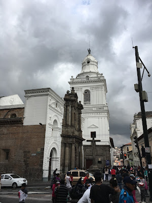
Since we finished early, Saturday turned into a free day to kill before heading to the airport at about 6pm. Daniel was down sick, so he stayed in the guest house while Mariah and I explored. First, we went to Teleferico where we took a cable car ride up above the city. It was an amazing view up there, even if it was a bit cloudy. In fact, the clouds made the scene amazing - we could watch as the clouds rolled up the mountain side like waves of air on the beach. After taking an obscene number of photos and selfies, we returned to the guest house to check on Daniel. He was still down, so we went to the vietnamese place I had been Friday night and got vietnamese pho noodle soup. That was something I never expected to find in Ecuador, but it was pretty good. Its interesting how different the soup is in different places; it is a goal of mine to try pho in as many countries as I can. After lunch, we took a taxi to the historic old town of Quito and wandered around a bit. We toured two different churches and then found a little Ecuadorian chocolate shop. Pretty nice place with history and culture and locals just hanging out, enjoying the day.

Well, that's it for me. I'll be heading on to a new institution before the next service run and network removal, so not sure how much I'll be involved. Its been a fun couple of trips and I'm excited about the data we're collecting. I'm very thankful to Susan and Anne for the chance to be a part of this experiment, NSF for finding money to fund this experiment, and the Geophysical Institute for supporting us.

Rob with Stephen and Hugo from the Geophysical Institute.

Some andesitic rocks on pichincha with a USD$1 coin for scale

Vietnamese beef noodle soup in Quito

Rob on the path to the Pichincha summit after the gondola ride up.

Panoramic view of Quito from the top of the gondola ride.

West of Quito from within the clouds

A view from the historic central part of Quito

Looking down on Quito from the gondola

Rob and Mariah on the Pichincha summit trail

Historic central Quito

Station located on a hill upslope from a school. The students were cutting the grass near the station, clearing a path for tsunami evacuation.

The teams met up at EC12 to plan the last push of the service run

Daniel and Xavier finish tying down the truck

Pollo en salsa de PiƱa while working on data transfer

Cutlets of chicken with potato and yuca and beans and rice

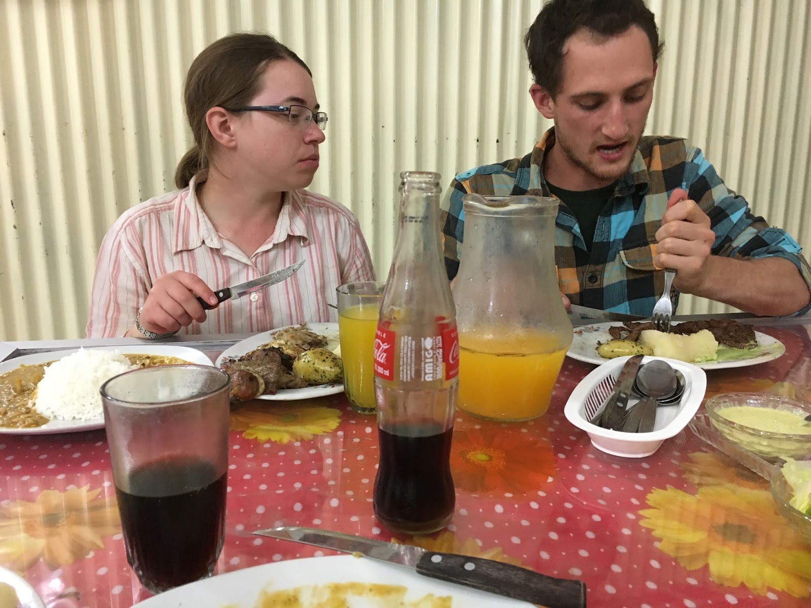
Mariah and Daniel at dinner on our last night before returning to Quito

A roadside stand on the way back to Quito

Wednesday, November 16, 2016

Full speed ahead!

Day two and wow was this a busy day. We were up by 6:30am to get our truck loaded and hit the road by 7am. Its great to work so early in the day because it doesn't really get too hot until mid-morning or noon. So working early helps minimize our hours under the brightest sun and also maximizes our hours of usable sunlight. We also helped our time by getting breakfast at a bakery in the morning and lunch at a supermarket the night before. In the end, we were able to get five stations serviced. That's pretty great because we were only scheduled to get three today. The other service team also was able to get five today and two yesterday, leaving us just six total. We're going to team up tomorrow afternoon to finish those off and hopefully be back in Quito by mid afternoon Friday.

Since we were so far ahead today, we had a chance to walk down to the beach in Tonsupa. We walked on the sand, saw some shops, and then had a great little traditional Ecuadorian dinner at a small restaurant. 

As we were driving, I was thinking a bit too much about a classic geo101 concept: U vs. V shaped valleys. I grew up, geologically speaking, in Michigan and Yosemite Park. Both of these are dominated by U shaped valleys. U shaped valleys form from slow glacial action wearing away the edges of a valley. Yosemite Valley is probably the most classic example and when I first saw it, my jaw dropped. In Ecuador, however, glaciers are pretty rare and so we see tons of V shaped valleys, everywhere. V shaped valleys form rivers running down hills or mountains. Nature never makes things that are perfectly uniform, but this is a pretty cool, easy to see, and useful geologic process indicator.


Our first station this morning. Love that bamboo fence!

Finished our fifth station on the data!

Nothing like finishing early enough in the day to get to the beach with a little bit of sunshine left

The beaches at Tonsupa are filled with colorful beachside wateringholes.

The beach at night, viewed from an excellent restaurant we enjoyed. 

Stretching our legs

The first day of the service run is coming to a close and it was a long, but successful day. Mariah, Daniel from the Geophysical Institute, and I are heading to the northern half of the array while Daniel and Xavier from the Geophysical Institute are heading south. Both teams serviced one station today, but plan to do 3-4 tomorrow and the day after that. Hopefully we'll then be able to meet up as a big team to move a site that needs to be relocated due to a land owner's request.

Interestingly, both Mariah and I have a common fieldwork friend named Nova. She did a master's degree at BYU where she co-led a field course in Indonesia and she has been absolutely amazing to work with on a deployment I worked on in Indonesia (bandaarc.blogspot.com). It can be pretty amazing how small of a field earth science can seem. We always seem to pop in and out of each others' lives and I think that drives a sense of community amongst many scientists. Arguments could be made whether that's good or bad for the science, but I've generally found it to be a healthy, supportive environment, even if we do have work to do to encourage under-represented groups to get out and play with rocks.

Random view from the road

Looking inside the electronics box of station EC04

Mariah and Daniel from the Instituto

Rob at EC04 (proof that I'm not just taking pictures and writing)

Getting ready for a night of calling landowners and downloading data

Saturday, November 12, 2016

Heading back to the field!

Our first service just ended about a month ago, but we're heading back down this week (13-Nov-2016 to 20-Nov-2016) to prepare the stations for the wet season. On the last service run we found out that many of the stations filled their storage faster than expected, probably due to a large number of aftershocks, which leads to difficulties in the compression algorithm and ends up creating bigger data files. So we're going down with compact flash cards with higher capacity in hopes that they will be able to store all the data through the rainy season. 

The field team this run is Daniel and Rob from Arizona and Mariah from Lehigh. We'll meet in Quito Sunday night, get prepared at the Instituto Monday morning, and head out to start work on Monday afternoon. Hopefully we can get a station done that first day, but it may be tough if road conditions aren't clear. Then we've planned on the service run taking three days (Tuesday, Wednesday, Thursday) and then we head back to Quito Friday and fly back to the States on a red-eye Saturday night to Sunday. 

Hopefully we'll have some field photos coming up in the next entries this week, but for now, here's a map highlighting the topography of Ecuador with earthquakes from the USGS plotted as black dots and stations in this aftershock deployment plotted as inverted triangles. These stations include stations from the US team, the UK team, and the French team. There's a lot of things we hope will be done with this data, such as improving locations of local earthquakes in Ecuador and helping us better understand the processes involved in active subduction. But, perhaps more importantly, the way seismology catalogs data means that this data will be available to be mined for hopefully decades to come.

Monday, October 3, 2016

Back from the first service run

The team recently returned from the first service run of the experiment. Service runs are used to collect the data that has been recording on flash cards and check to make sure everything is running properly. We had two teams of two from the US on this run: Colton and Daniel from University of Arizona and Anne and Mariah from Lehigh University. Colton and Anne were part of the initial install, so this was a great chance to bring two early career graduate students into the field and help train them on the specifics of this deployment.


Street sign for Pedernales
One of the more challenging aspects of a deployment is coming up with a good acronym or project name. The field teams came up with a few options on this run:
IPAD - International Pedernales Aftershock Deployment
PADRE - Pedernales Aftershock Deployment Rapid Experiment
MADRE - Muisne Aftershock Deployment Rapid Experiment
MADRE(2) - Multinational Aftershock Deployment for the Rupture in Ecuador
READIE - Rapid Earthquake Aftershock Deployment In Ecuador
EPIC Experiment - Earthquake in Pedernales International Collaborative Experiment
NERD - Northern Ecuador Rapid Deployment
We'd definitely appreciate input on which one is best (or other suggestions!) so please feel free to leave a comment on this post.
Colton on the top of a photogenic mountain
Daniel with a view of the city on a cloudy day.

One of our stations, overlooking a small town.

Mariah, working hard.

Roads amongst the clouds

Anne, checking the station status.

Wednesday, May 18, 2016

Another M6.8 aftershock

Today, around 11:45am, we felt another moderately large sized earthquake. This one occurred in a very similar location as last night's earthquake with virtually the same magnitude and moment tensor. It was pretty frightening as we were on the 8th floor of a building built in 2 parts and we watched as the parts swayed relative to each other and then we exited the building with a large crowd. We're ok; the shaking was pretty far away from Quito. Now we're just preparing to give a short talk at the Instituto about our (Susan's) research in South America and thank them for all their help. So far its been a successful deployment, but the real test will come in four months when we service the stations - ie pick up the data and check on station health. That's all for now, hopefully we'll have some updates when the team heads back down here!

Moon over a waning day in Quito, looking east.

Large aftershock

We're in Quito and just felt a large (M6.7) aftershock in our hotel at 3am. The shaking was moderate, (MMI IV), but enough to be frightening. I've just heard some sirens, 20 minutes after the shaking so the local emergency response teams seem mobilized. I'm really worried about the landowners we've met with over the last week. We've documented some of the damage 2-3 weeks after the mainshock and I expect there is some more similar damage near the epicenter of this earthquake.

Scientifically this is a strange event. Aftershocks approximately 1 magnitude unit less than the main shock should only occur within the first week or so, and thus this one is bigger than would be expected. However, it is in some sense fortuitous as we've just finished our deployment and this quake is in the center of our network. So we should have very good recordings of this earthquake.

http://earthquake.usgs.gov/earthquakes/eventpage/at00o7d4r3#general

USGS map of Rosa Zarate event. M6.7

Tuesday, May 17, 2016

On the way home

With the last stations deployed, Susan, Roberto, Evan, and I returned to Quito. On the way we had a little car issue, as must happen on every deployment, but it wasn't serious and we got it fixed easily. It still cost us some time, but it felt good to have it fixed. On the road we had some nice scenes through the mountain jungles. Most of the skies were too cloudy to see much, but we still got to see a waterfall and a demon face carved into the side of a mountain. I don't usually do selfies, but thought a couple were appropriate here.

It feels good to be done. We have a few more things to square up with the institute, but we have 19 new broadband stations installed in Northern Ecuador. In about 4 months we'll be back for a service run to pull the data and ship it to IRIS. Once there, it will be open and available for anyone who wants to do science with it. I personally may not work too much on this data, but I look forward to having a peak at some wiggles.


Waterfall en route to Quito

El Diablo Tanabi

El Diablo and Rob

Clouds enveloping the mountains

random selfie. Not a professional selfie pose, but c'est la vie.

Monday, May 16, 2016

All stations deployed!

Last two stations went into the ground today! We're done and heading back to Quito to fly back to the States. We started the day in a town called Chone. Anne, Colton, and Mario had to head back to Quito today, so we started with a little breakfast, then split up the trucks into what can go back to Quito and what we needed in the field. We took two trucks to find two sites. The first one is in a town called Montecristi, west of the hub town of Porta Veija. It was a hard site to dig; we hit rock within about 30cm, so our site was buried relatively shallowly. That should be good though, as hard rock sites give the clearest ground motion. The second site was on the other side of Porta Veija, to the south, in a town called Sucre. It was a hard site to find because all the people we met were renters or didn't have a good, clear, well-drained, and secure spot to build the station. However, we eventually found a spot near the last house on the road. The families that live there were kind and helpful, so we took some photos with them as we left. On the way back to Chone, where Susan, Evan, Roberto, and I are staying again, we passed through Porta Veija to take pictures of the damage. Even though this town is pretty far from the main shock in Pedernales, it appears that limited pockets of the town were hit very hard by the shaking.

Just as a few days ago I was hit by a sense of, "what am I doing here", today I was reminded of how wonderful my job is. I really never took myself as the type of person who'd just uproot everything I've been doing and travel to rural parts of the world, but here I am. Its a fantastic opportunity to see the world as it actually is and not just have the narrow view of what life is like in my house, town, state, country, etc... Really interacting with people in small towns in Ecuador has been fantastic. I'm getting a better feel for what life is like in different parts of the world and it makes me wonder what is best, or more fittingly, what is it that makes me happy in a place that I'm living? I know there's no single answer, but exploring the possibilities is amazing.

View of EC19

Pretty much every meal here, other than breakfast, has included lentils and rice

Team and family selfy at EC20

Some damage in Porta Veija


Damage in Porta Veija

Damage in Porta Veija

Saturday, May 14, 2016

The NERD deployment is almost done!

We've got 6 stations left for the Northern Ecuador Rapid Deployment. Four should go in tomorrow and then Anne, Colton, and Mario, the director of the Instituto Geophisica, are returning to Quito. Susan and I will then finish the last two stations before heading home Thursday night.

Today we met with a really fantastic landowner. It's a couple who own a large amount of land near Pedernales and are preparing it for a housing development. They have lots of beautiful open land in the mountains providing for clear sky views and quiet sites. Perfect for our ground motion sensing instruments powered by solar panels. They were interested in seismology and geophysics and spent the afternoon with us while we installed. It takes extra time to install a station and interact with folks, but it is so rewarding to meet people who care about what we are doing. It really made me feel good about the site and the deployment overall. So a nice boost of positivity is helping lead us into the home stretch.

I thought today I'd make a deployment map. I've only put in the main shock and shaded the approximate area we are deploying in, but hopefully it shows that we're really covering the region near the earthquake. Once some data is at the IRIS DMC we'll be able to more readily make the station coverage maps. Hopefully we'll also have locations from the French and UK groups to make the full collaborative deployment show in its full glory.

Today's drive through the damaged city of Pedernales was really an eye opener. We see pictures on tv or the internet trying to portray the devastation, but it doesn't hit you until you see it first hand. We're sad for the lives that are lost and those that need to pick up and start afresh. Everything you've worked your life for is gone in seconds of strong shaking and then short jolts of weaker shaking remind you of your loss. It is easy for us, sometimes, to sit in a comfy armchair and think about what the wiggles of the seismometers tell us about the earth, but we must always keep in mind that those wiggles are generated by disasters.

A building destroyed in Pedernales

A building destroyed in Pedernales


Lunch - pork with lentils, rice, and plantains

At EC16 - "ANNA" with myself (Rob), Evan from IG, and the landowners, Larry, and Anna.

EC16 with Susan, Evan, Larry, and Anna

Location map with the main shock near the coast, volcanoes in red, and our approximate deployment area in shaded yellow (note, we are only deploying on land, no ocean bottom seismometers in this deployment).