Wednesday, May 18, 2016

Another M6.8 aftershock

Today, around 11:45am, we felt another moderately large sized earthquake. This one occurred in a very similar location as last night's earthquake with virtually the same magnitude and moment tensor. It was pretty frightening as we were on the 8th floor of a building built in 2 parts and we watched as the parts swayed relative to each other and then we exited the building with a large crowd. We're ok; the shaking was pretty far away from Quito. Now we're just preparing to give a short talk at the Instituto about our (Susan's) research in South America and thank them for all their help. So far its been a successful deployment, but the real test will come in four months when we service the stations - ie pick up the data and check on station health. That's all for now, hopefully we'll have some updates when the team heads back down here!

Moon over a waning day in Quito, looking east.

Large aftershock

We're in Quito and just felt a large (M6.7) aftershock in our hotel at 3am. The shaking was moderate, (MMI IV), but enough to be frightening. I've just heard some sirens, 20 minutes after the shaking so the local emergency response teams seem mobilized. I'm really worried about the landowners we've met with over the last week. We've documented some of the damage 2-3 weeks after the mainshock and I expect there is some more similar damage near the epicenter of this earthquake.

Scientifically this is a strange event. Aftershocks approximately 1 magnitude unit less than the main shock should only occur within the first week or so, and thus this one is bigger than would be expected. However, it is in some sense fortuitous as we've just finished our deployment and this quake is in the center of our network. So we should have very good recordings of this earthquake.

http://earthquake.usgs.gov/earthquakes/eventpage/at00o7d4r3#general

USGS map of Rosa Zarate event. M6.7

Tuesday, May 17, 2016

On the way home

With the last stations deployed, Susan, Roberto, Evan, and I returned to Quito. On the way we had a little car issue, as must happen on every deployment, but it wasn't serious and we got it fixed easily. It still cost us some time, but it felt good to have it fixed. On the road we had some nice scenes through the mountain jungles. Most of the skies were too cloudy to see much, but we still got to see a waterfall and a demon face carved into the side of a mountain. I don't usually do selfies, but thought a couple were appropriate here.

It feels good to be done. We have a few more things to square up with the institute, but we have 19 new broadband stations installed in Northern Ecuador. In about 4 months we'll be back for a service run to pull the data and ship it to IRIS. Once there, it will be open and available for anyone who wants to do science with it. I personally may not work too much on this data, but I look forward to having a peak at some wiggles.


Waterfall en route to Quito

El Diablo Tanabi

El Diablo and Rob

Clouds enveloping the mountains

random selfie. Not a professional selfie pose, but c'est la vie.

Monday, May 16, 2016

All stations deployed!

Last two stations went into the ground today! We're done and heading back to Quito to fly back to the States. We started the day in a town called Chone. Anne, Colton, and Mario had to head back to Quito today, so we started with a little breakfast, then split up the trucks into what can go back to Quito and what we needed in the field. We took two trucks to find two sites. The first one is in a town called Montecristi, west of the hub town of Porta Veija. It was a hard site to dig; we hit rock within about 30cm, so our site was buried relatively shallowly. That should be good though, as hard rock sites give the clearest ground motion. The second site was on the other side of Porta Veija, to the south, in a town called Sucre. It was a hard site to find because all the people we met were renters or didn't have a good, clear, well-drained, and secure spot to build the station. However, we eventually found a spot near the last house on the road. The families that live there were kind and helpful, so we took some photos with them as we left. On the way back to Chone, where Susan, Evan, Roberto, and I are staying again, we passed through Porta Veija to take pictures of the damage. Even though this town is pretty far from the main shock in Pedernales, it appears that limited pockets of the town were hit very hard by the shaking.

Just as a few days ago I was hit by a sense of, "what am I doing here", today I was reminded of how wonderful my job is. I really never took myself as the type of person who'd just uproot everything I've been doing and travel to rural parts of the world, but here I am. Its a fantastic opportunity to see the world as it actually is and not just have the narrow view of what life is like in my house, town, state, country, etc... Really interacting with people in small towns in Ecuador has been fantastic. I'm getting a better feel for what life is like in different parts of the world and it makes me wonder what is best, or more fittingly, what is it that makes me happy in a place that I'm living? I know there's no single answer, but exploring the possibilities is amazing.

View of EC19

Pretty much every meal here, other than breakfast, has included lentils and rice

Team and family selfy at EC20

Some damage in Porta Veija


Damage in Porta Veija

Damage in Porta Veija

Saturday, May 14, 2016

The NERD deployment is almost done!

We've got 6 stations left for the Northern Ecuador Rapid Deployment. Four should go in tomorrow and then Anne, Colton, and Mario, the director of the Instituto Geophisica, are returning to Quito. Susan and I will then finish the last two stations before heading home Thursday night.

Today we met with a really fantastic landowner. It's a couple who own a large amount of land near Pedernales and are preparing it for a housing development. They have lots of beautiful open land in the mountains providing for clear sky views and quiet sites. Perfect for our ground motion sensing instruments powered by solar panels. They were interested in seismology and geophysics and spent the afternoon with us while we installed. It takes extra time to install a station and interact with folks, but it is so rewarding to meet people who care about what we are doing. It really made me feel good about the site and the deployment overall. So a nice boost of positivity is helping lead us into the home stretch.

I thought today I'd make a deployment map. I've only put in the main shock and shaded the approximate area we are deploying in, but hopefully it shows that we're really covering the region near the earthquake. Once some data is at the IRIS DMC we'll be able to more readily make the station coverage maps. Hopefully we'll also have locations from the French and UK groups to make the full collaborative deployment show in its full glory.

Today's drive through the damaged city of Pedernales was really an eye opener. We see pictures on tv or the internet trying to portray the devastation, but it doesn't hit you until you see it first hand. We're sad for the lives that are lost and those that need to pick up and start afresh. Everything you've worked your life for is gone in seconds of strong shaking and then short jolts of weaker shaking remind you of your loss. It is easy for us, sometimes, to sit in a comfy armchair and think about what the wiggles of the seismometers tell us about the earth, but we must always keep in mind that those wiggles are generated by disasters.

A building destroyed in Pedernales

A building destroyed in Pedernales


Lunch - pork with lentils, rice, and plantains

At EC16 - "ANNA" with myself (Rob), Evan from IG, and the landowners, Larry, and Anna.

EC16 with Susan, Evan, Larry, and Anna

Location map with the main shock near the coast, volcanoes in red, and our approximate deployment area in shaded yellow (note, we are only deploying on land, no ocean bottom seismometers in this deployment).


Friday, May 13, 2016

Another day in the books; 4 more stations in the ground

Today was a bit shorter for my team. The drive to the area wasn't bad and the landowners at our first attempted sites were home and agreeable; they even helped us install the stations including helping with the digging and building fences for us. Usually we'd build our own fences, but we're on a tight schedule and folks usually will know what works best for fences on their land. 

Since we worked tough yesterday, we were able to stop for a really good quick lunch. Usually, I tend to just get snacks in the morning and work through the mid-day to maximize daylight. But we had time and were able to find a place with set lunch, so it only cost us about 30 minutes, which is not bad and really made the afternoon feel better. 

I'm really liking our station design. I think we'll get very good data out of these stations, so I'm looking forward to checking out some wiggles. The whole deployment, including the US, UK, French, and Ecuadorian stations looks to be quite dense. This should make for some very nice wavefield images, but will be very interesting to see how well the mixed deployment will work - we are putting out broadband instruments, whereas many of the other instruments are short to intermediate period sensors. 

Sensor in the ground, on a granite pad and the electronics box being filled.

Station EC14 - the sensor in its home. 
View from EC14

Sensor buried, just need to mount the solar panel.

Some last touches with the son of the landowner. 
The team - from left: Christian, son of the landowner, Susan, landowner, and Carlos (or Carlitos). This was taken before the next image. Notice the tree branch over the team.

After hacking off a tree-branch with a machete.

Susan checking the power system with family from EC15

A nice little sunset in the clouds.

Thursday, May 12, 2016

Northern Ecuador Rapid Deployment

Today was the first day on this trip I thought to myself "what in the world am I doing here?". Flying down on short notice to an area recently devastated by an earthquake is not my usual Monday. But here we are, working with locals, finding sites, and deploying stations. Four shiny new stations were installed today along the coast. Everything is muddy and much of the area is below sea level and often flooded. So the challenge is to find good, solid, high ground. So far we've been lucky; regions only have 1-3 viable sites and we're finding them and installing quick. 

From the truck; view of people rebuilding.

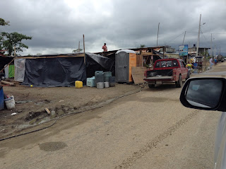
Some small tents. We passed many tent cities on the way, so its good to see humanitarian efforts are on their way, but never can be fast enough.

Susan with a fancy berry juice at dinner.

EC13 all ready to record

EC13, nearly done. Proof that professors get out and get dirty in the field.

Wednesday, May 11, 2016

First field day completed!

We've successfully completed day 1 of actual field work! Two stations are in the ground. It was hot and humid and hot, so the work was slow, but we've got two good looking sites installed. The long days and hot weather are tough on team morale, so my team took it a little easy and retreated to the hotel to regroup after just one station. I took the chance to enjoy the sunset and once the other team arrived we had a nice dinner at the hotel. Susan, Anne, and Mario are now planning out logistics for the next day. I'm hoping we get two sites per team, maybe even start to lay the basic work on three. Our station design is really not tough to install, its just a matter of building the team work and dealing with the heat.

Our current base in Atacames is really fantastic. Its a little beach front town that seems mostly to cater to tourists looking to get away. My team will likely be driving west and down the coast from here tomorrow, coming closer to the epicenter near the towns of Pedernales and Musine. 


Susan and Christian discussing the site.

Our station boxes are supporting the solar panels. This provides a little extra protection from rain and heat, but is really only possible in low latitudes.

Finishing up the site

The sun is setting over the beach from the htoel.

A beautiful sunset in all its glory.


Monday, May 9, 2016

First day in Quito

Today was our first full day in Quito. After a quick breakfast of granola, cereal, eggs, and most importantly, coffee, we walked from our guest house to the Instituto Geofísico at the Escuela Politécnica Nacional (IG-EPN) and met with collaborators there. We were helped quite a bit by a friend of mine, Stephen Hernandez, who is a volcano seismologist here at the Instituto. He contacted one of their drivers, Javier, to drive us around for shopping. We picked up most of the equipment we need for stations and then had a short meeting Mario Ruiz, the director of the Instituto, and a pair of French researchers from Nice who are deploying another component of the array.

Tomorrow our large rental truck will arrive and we'll load up and head out to the coast to begin the deployment. Our first stations should go in the ground on Wednesday, so we'll hope to have some actual field photos up soon!

The US group walking to the Instituto


You see buckets, we see station vaults.

The city is built on a mountain, but hopefully this shows how cloudy it was here in Quito today.

One of the Instituto's trucks.

A warehouse full of vaults!

Sunday, May 8, 2016

En route to Quito

Colton, Susan, and I (Rob) are currently waiting for our connecting flight from Houston to Quito, Ecuador. We're planning to meet Anne once we arrive and relax for the night. Tomorrow, we have to do local shopping for various tools and components we're unable to bring from the states. Tuesday morning we'll load up a big truck with all the equipment from PASSCAL and drive west to a setup a field depo and hopefully we'll get out and install a station as a team. Usually, the first install of a deployment is a big group install with everyone working together on one sight; it makes for slow work, but its good to make sure everyone knows what the station design is before we separate into smaller teams. However, since we're short on time, we may skip the team install and just split up to get two stations done Tuesday. Anyways, these last minute logistical details will be hammered out once we arrive.

We've got some good news regarding international collaboration. Teams from the US, UK, France, and Ecuador will all be down there at the same time and we'll be working together to share resources and prepare the ideal array geometry.

I'm looking forward to some field photos once we get the stations in the ground. Maybe some food photos too, once we get some local cuisine. Right now my mind is just racing with thoughts of "did we bring everything? What will conditions be like on the ground? What will the food situation be like? How often will we be camping? etc..."

Monday, May 2, 2016

Science in the wake of a major earthquake

Big earthquakes have big impacts on society. The M7.8 earthquake near Muisne, Ecuador occurred on April 16th, 2016 and has caused hundreds of deaths, tens of thousands of people displaced, and estimates of the damages are in the billions of dollars. Our understanding of Plate Tectonics helps inform us about where earthquakes are likely to occur and how big they may be, but we may never be able to forecast earthquakes on the appropriate time and spatial scales for effective warnings before the rupture begins. However, aftershocks, or small earthquakes following a large earthquake, can continue for months to years after the mainshock and characterizing these aftershocks may provide important insights into processes within the earthquake cycle. This blog will follow a Rapid Array Mobilization Project (RAMP) deployment in Ecuador led by researchers at Lehigh University (Anne Meltzer and Josh Stachnik) and the University of Arizona (Susan Beck, Colton Lynner, and Rob Porritt). We are collaborating with Mario Ruiz at Instituto Geofisico – Escuela Politecnica Nacional from Ecuador and international groups from France, Germany, and the U.K.
Shake map for the M7.8 16 April 2016 earthquake (http://earthquake.usgs.gov/earthquakes/eventpage/us20005j32#general)
The earthquake occurred ~2 weeks before this blog post and we're heading down in a couple days, planning to arrive May 6th. We have 20 broadband sensors from the PASSCAL instrument center awaiting us at the US Embassy, but we'll need to get local tools and building materials in Ecuador. Hopefully Monday, a week from this post, we'll be heading to a staging area in western Ecuador to clarify plans and start the deployment.